Hands-Free Hiking: Garmin Venu 3 and Komoot. Alps Test
Introduction
This summer, I hiked in the Austrian Alps. As usual, I relied heavily on Komoot. Last year, I paired Komoot with my Galaxy Watch (check “Galaxy Watch + Komoot + Hiking: Battery Usage” if you want to read about that experience), but this time, I used it with my new Garmin Venu 3.
Komoot is an excellent tool, offering advanced functionality even without a subscription (although you still need to purchase region maps to use most of them in the field). I’ve bought a few regions and got more for free through my health insurance. As a result, I have maps for all areas I might hike in the foreseeable future.
Additionally, Komoot offers offline maps and guided navigation for Garmin watches that don’t have Garmin maps, like my Venu 3.
Planning and Preparation
Many trails for this vacation were found directly in Komoot based on regions and summit names, while others were imported from different sources. I used the web version of Komoot to plan all my hikes. The photos uploaded by others were especially helpful in estimating trail difficulty.
For planning, Komoot works great! As usual.
On the Path: Navigating with a Smartphone
I find Komoot on the phone excellent for navigation. On top of navigation as such, it offers plenty of useful information. It can even reroute your tour dynamically if you changed your mind or missed a turn, although this requires an internet connection. However, constantly taking my phone out of my pocket—especially in the mountains, with poles in hand – isn’t convenient.
The ideal solution would be a companion mode: full navigation on the smartphone, with key info on the watch. Unfortunately, this setup isn’t available, so this time I used my watch as my main navigation device.
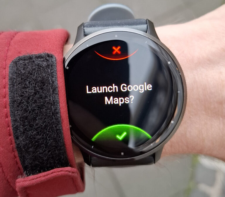
When I needed to see a map or check alternative routes, I pulled out my phone. Komoot would show my current location and the planned route, more or less like a paper map would do – nothing fancy, but enough.
However, there is one thing to be aware of.
Offline Maps Aren’t Fully Offline
I downloaded all my tours for offline use, but I learned the hard way that the list of tours itself isn’t stored on the device. At the starting point of one hike, I opened the Komoot app to check the route and send it to my watch, only to find an empty “planned tours” list. The tours were likely stored on the phone, but I couldn’t access any of them – what a bad humor!
In this case, it wasn’t a big deal as I knew where to go, and the internet came back after walking 50 meters. But I also considered hiking in Switzerland, where EU “free-roaming” rules don’t apply. There, this Komoot “feature” could have cost me data roaming charges — very frustrating.
On the Path: Garmin Venu 3 in Action
How It Worked
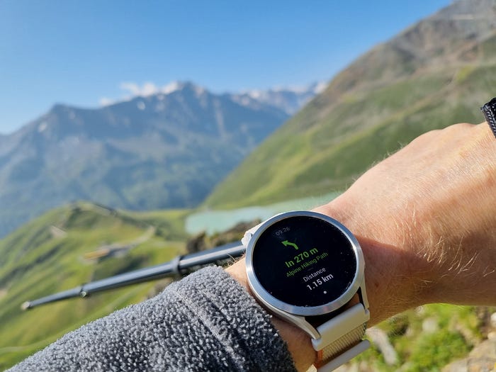
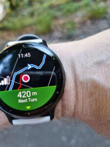
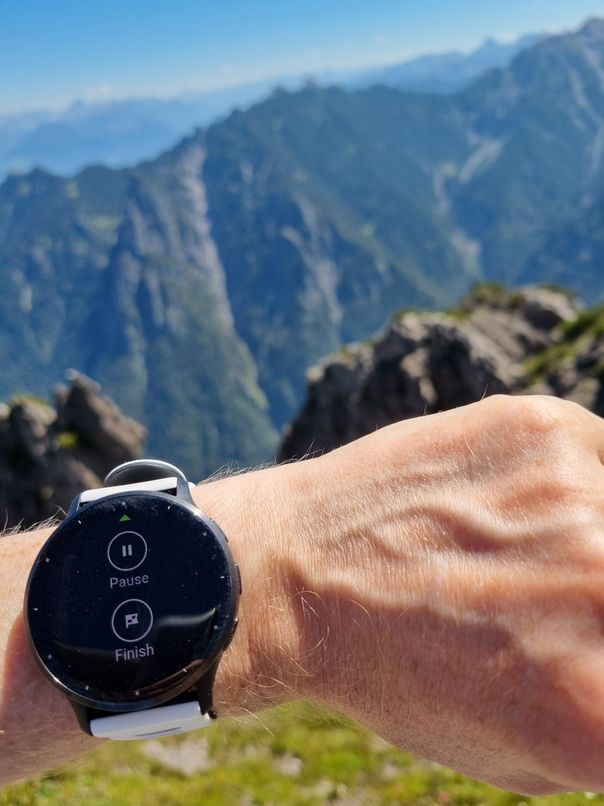
I intentionally used my Garmin Venu 3 as the main navigation device, and I have to admit – it worked pretty well! Alpine paths are marked, so you don’t need to check the map constantly. But the ability to glance at the screen and get key information was incredibly useful.
I mostly checked the following:
- A breadcrumb map to confirm my direction
- Distance until the next turn
- Time since start
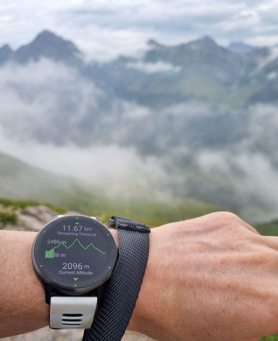
- Traveled and remaining distance
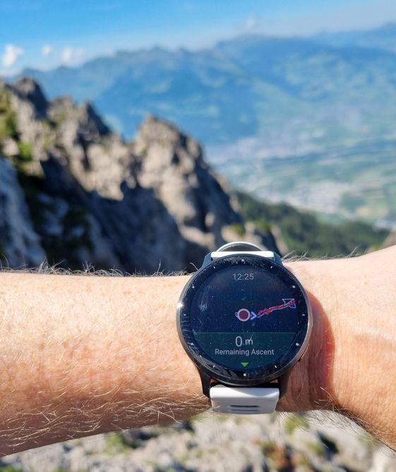
- Elevation profile and remaining ascent
The watch vibrates at each turn (which is configurable), ensuring I didn’t miss any (and I really did not). This allowed me to comfortably follow my route, only taking my phone out a few times during the entire two-week trip.
To see another data field on the map screen one should tap on it.
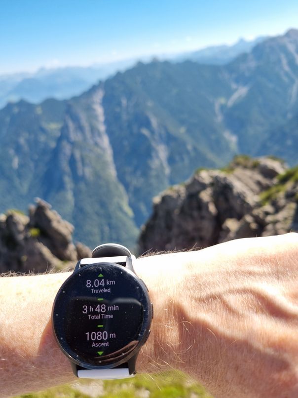
Battery life wasn’t an issue either. For long hikes I only needed to make sure the watch was charged the night before. I was able to track my sleep, use the watch during the day, hike, and continue tracking in the evening – all without recharging. For shorter hikes I did not need even that, more than 50% a night before – good enough. This was a game-changer for me! More about how long battery a smart watch really needs in “Smartwatch Battery Life: What’s Truly ‘Good Enough’?“
Additionally, all my hikes were automatically logged in Garmin Connect, and counted towards all challenges and badges (I earned a few of them during this vacation).
What I Missed
While it worked well, there were a few things I missed:
Information on the remaining descent
Key route points on the watch’s map (like Komoot on the phone)
Remaining distance, time, and ascent/descent to a key point—especially useful when gauging time to the summit.
Remaining descent – the part of the path with 1000 m descent is often harder than a one with 1000 m ascent.
Things I Didn’t Like about Komoot/Garmin Integration
Hiking vs. Walking
Komoot hikes are recorded in Garmin Connect as walks, which means I had to manually change the activity type after each hike in the app. Unfortunately, this change doesn’t sync back to the watch, so my “weekly exercises” stats on the watch showed swimming and walking.
This was frustrating – why can’t Komoot activate hiking when using the Garmin engine?
Misleading Pause Feature
Komoot has a “pause” option, which seems useful. But when I paused a hike, it automatically ended after 5-10 minutes (no questions asked).
My assumption here is the following: Venu 3 doesn’t support “resume later,” Komoot uses Garmin engine for tracking. When I paused tracking in Komoot, it paused underlining Garmin exercise. And when Garmin automatically stopped tracking, so did Komoot. This wasn’t obvious at first and one of the hikes was split into two separate activities.
Komoot Sync Issues
When you setup connection between Komoot and Garmin, it asks if Komoot can read Garmin activities. I made a mistake and allowed this. Komoot immediately imported all my walks from Garmin – spamming my Komoot app. I use Komoot for hiking, therefore I didn’t need all those short “after a lunch” walks. After cleaning up this noise, I disabled Garmin-to-Komoot synchronization.
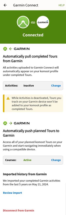
As a result, my Kommot hikes were recorded in Garmin Connect but not pushed to Komoot servers. I had to export tracks from Garmin Connect and import them manually into Komoot.
Unfortunately, the Garmin Connect app doesn’t offer GPX export, so I had to use the web version on a mobile browser. This added unnecessary steps to the process. For these imported tracks, Komoot also showed 0 moving time, which was annoying.
Summary
Even with just a breadcrumb map (as full maps require a subscription), Komoot on the Garmin Venu 3 was highly usable for navigation. Using the watch for navigation allowed me to keep my phone in my pocket (well, except when taking photos or videos).
However, not everything was perfect—there are still a few limitations and bugs that need addressing.
Last, but not least: if you are going to use Komoot for your hiking, I strongly recommend to test it works doing dry run tests around your home.